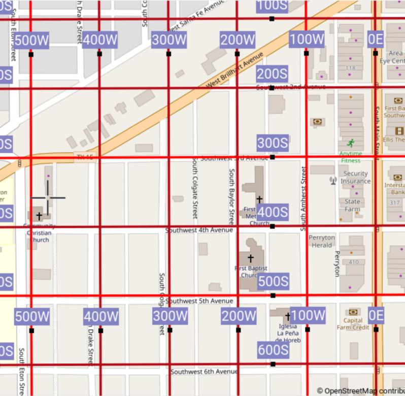
(A demonstration for future Openstreetmap implementation. Part of Putting address grids back on the map. User grid entry inspiration and sub-project page.)
Today we are going to add address grids to Perryton Texas! Hey, kids, are you as excited as me?
OK we open the iD editor (not exactly now, (it doesn't have all the cool features yet,) but in a couple of years) and go to Perryton, Texas, USA. Bet they weren't expecting us. Well they'll be eternally grateful to us before the day is through. OK. We need to hunt around for the "minimum of three ground control points" needed for our grid to be accepted by the iD editor and thus Openstreetmap.
OK, our eagle eyes swoop down on this church, It's not a Sunday but we've arrived (at least in the editor) anyway, ready or not. Based on its address "1000" there in the side panel and the name of its avenue (Southwest 15th Avenue, i.e., 1500 S. Get it?), we can click the intersection it is at, and enter with confidence into the "1st point's address coordinates" box: [1000W 1500S].
OK, now like a vulture we go hunting for our next "ground control point". OK, there it is.
I know, you're going to say, "There's nothing there, Nerdsworth. You just stuck it in the middle of Main Street." Ah, but look at what we enter into the "2nd point's address coordinates" box: [0, 0]!
Yup, look around. See? That's where Center Avenue would have hit Main Street if the stupid certain former now invisible railway hadn't messed things up.
And yes, everybody knows that Center Avenue and Main Street is "ground zero" of house addressing in these parts of the US.
Ho hum. Now for our third and final ground control point. (Hey, sounds like "Ground Control to Major Tom.") Well let's get lazy and just put it at the right angle our previous two points make with each other. That's correct, at the corner where Sudzy Springs Car Wash lies!
I know what you're saying, "Nerbleston, wouldn't it be advisable to at least check the address of said aforementioned car wash?" Well we did, and by gosh it didn't have an address in OSM, yes, as you can see if you had, oh, bothered to click it. In fact the car wash must be close to 1500 S. Main St. But all that doesn't matter, as we can still confidently enter [0 1500S] for our last point.
Click "Finished". Now it asks us what areas the grid should apply to, Perryton? Ochiltree County? We choose Perryton, and "foosh", we are now staring at our grid!

Previewing immediately reveals
Amherst Street is 100 West (-100),
Baylor Street is 200 west,
Colgate Street is 300 West
Drake Street is 400 West...
Eton Street is 500 West...
And hold everything. Our European etc. friends don't know what we are talking about still one single bit. You can't blame them. Where they grew up most streets were distorted, crooked, and kinky, so grids never got a fighting chance.
Hello European etc. friends. Please observe the right side of the map. Do you see house numbers 118, 317, and 410? Notice how they confirm the accuracy of our grid lines?
Sure, the grids lines slip a little as we head southwest. They don't exactly obliterate the street names. People can still see the names because our lines don't exactly run down the streets' center lines.
But we are only previewing how our grids line up with the streets. This is not the final map. We're in the editor, remember?
What is the final map? There could be 1000 different final maps. That's the beauty of Openstreetmap. It is up to the rendering people to determine how they want to use the data to make their final map. Some maps could have the grids with blue lines. Some with just black "+" grid ticks. Some with just a graticule around the edges. It's none of our business. OK?
Oh yeah, our points are not on the centerlines. But hey, we'll add some more ground control points later or something. It's time to get a refreshing glass of watermelon juice to congratulate ourselves for a job well done.
We click "Save", fill in the Changeset comment "Initial grid. Will refine after lunch. I promise." and see "You have just edited Openstreetmap around Ochiltree County..."
Anyway we can now skateboard around Perryton, with Total Grasp™ of its addressing grid!
The "competition", e.g., Google maps, only shows some house numbers. No grids (yet. I sincerely wish they would hurry up and hop on the bandwagon.) And then of course we see "Southwest 3rd Avenue" which anybody can guess is 300 South. But sorry, no Total Grasp™.
So our teacher grabs us by the ear and pulls us back into the classroom and asks just why did our map look bad.
Hey don't blame me. Maybe that town has crooked teeth. You know, irregularly spaced roads.
Or maybe we were to rambunctious, too adventurous, and should have not gone more than a mile before making another ground control point. Maybe any underlying "PLSS sections" were not perfectly aligned, affecting the streets that are based on them.
As a matter of fact did you know that for "PLSS states", one doesn't even need manual editing! (Uh, Texas is not a PLSS state.)
Last modified: 2024-05-26 11:23:30 UTC